Friday, July 8, 2022

La Tortue, mets tes cossins et gonfle tes ailes d'eau!

In 2020, a hot new video (that you can watch here!) hit the internet, it was an awesome group of québécois kayakistes running the Tortue for the first time. The video hit hard, getting noticed by kayakers all around for it's good quality and production values, not to mention intelligently chosen rapid names. After having done this run, it's pretty incredible the work they put into this video, thanks to them!

I was on a trip in West Virginia with some québécois friends in May when one of them mentioned being invited on a Tortue trip that they couldn't make, and I might get the replacement invite. I'm in the fortunate situation of being invited on expeditions as a replacement from time to time, which is great and very lucky! Sure enough, mid-late May rolled around and the invite came in! I said yes, and managed to juggle it between a ton of administration related to my move at about the same time from Petawawa to Borden, Ontario.

In mid-late-June (during my move) I headed to Québec to join my buddies Étienne, Romain and Simon after my customary supper at La maison Marocaine. We headed up in the Caravan to Sept-îles and the next day boarded the hydravion bound for lac Tortue. The flight was awesome, it was my first time in a float plane, and the pilot did some pretty sweet banking around the lake before taking us down. He managed to back the plane right up to the rocks, we probably could have got off the plane without even touching water!

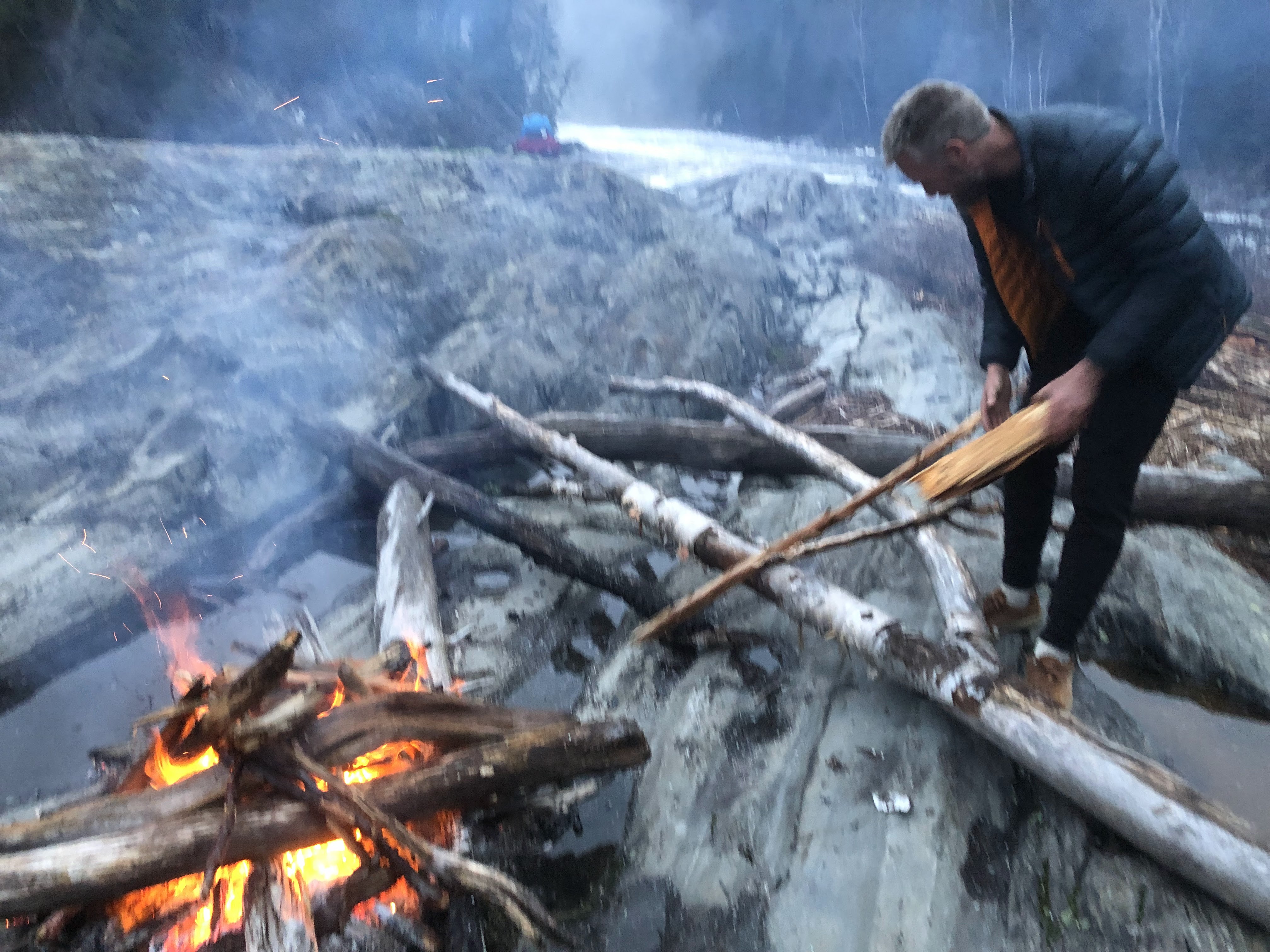
As the plane took off, the reality would set in that we were in a cold, windy, remote area as we were staring at a nice big bank of snow beside us. We found some shelter, made a nice fire and set things up, using the snow as a fridge for our beer we brought for the night. Étienne caught a delicious trout which made for a nice appetizer. It did get cold that night! This brings up an important point though, cold vs bugs. Take the cold. We were on the river as the bugs came out, and the last day they made horrendous, even though we were prepared with nets and such. I highly suggest if you can, timing this run pre-bugs or later in the season when they die down a bit if you can!

When it comes to levels, you never really know with the Tortue. It can be flashy-ish, there is no gauge, but the nearby Magpie and Moisie both have gauges. I'd say the level in the video is pretty ideal looking, we had a bit more, but it was manageable as well, though it might have spiced things up a bit. We would have all rated the run class IV-V instead of IV+, I portaged a couple more things than the rest of the group, which was mostly fine, I would caution though, not to go in there expecting to portage things regularly, you're best ready to run the river if you go! The river has some snowmelt early on, and is rain based after that, I'd say it is not a bad idea to have a backup in case there's no water.

We did the run in 4 days, minus being dropped at the lake the evening prior. If you were dropped in the morning, you could do it in 4 days at a normal pace, 5 relaxed (or filming heavily maybe), 6 would be super chill. We did not choose the best campsites, we camped at the lake, just at the start of splinter canyon (the crux, and I was not a fan of waking up to the crux!), and then down in the 40 km of flat between the middle and lower. I highly suggest camping at the exit of lac Elinore, getting through Splinter canyon the following day and then choosing some nicer sites on the way after that.

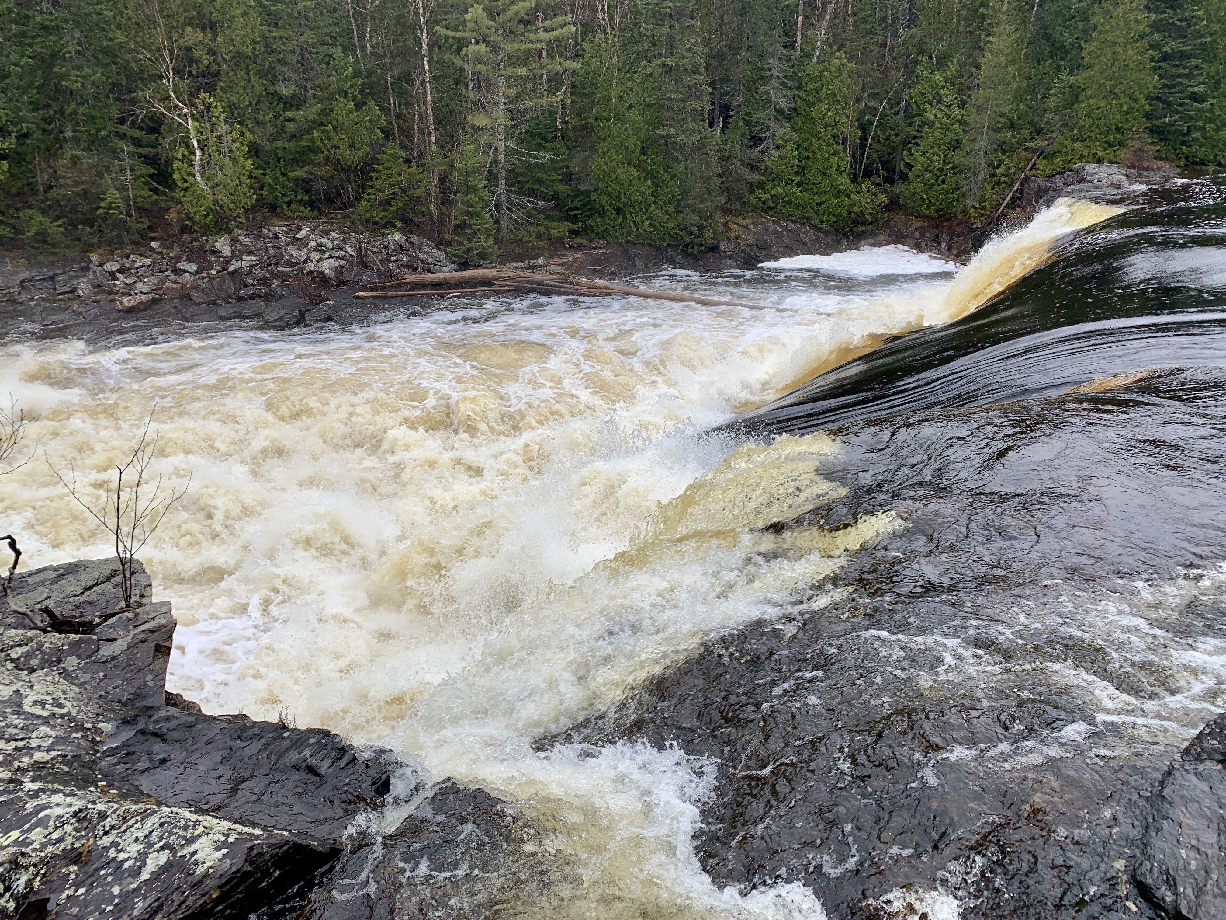
The run itself is pretty choice. A couple lakes off the bat, long spreads of continuous boogy, and some quality canyons with a couple km (3-7 each) of flats between..eventually you hit Cowabunga, the main even 30 foot slide/falls with some technicality, and then ....surprise, more quality rapids until a messy hallway rapid with a sharks tooth in the middle before 40 km of moving flats floats you to the lower. The lower 2 km is no joke either, some big rapids, and likely some portages before you take out at the highway.

I thought this river was a treat, better bang for you buck rapid wise than Magpie ouest, and not even the same game. Don't necessarily think you can do this because you can do the Magpie ouest (unless you ran ALL the rapids there), this one is a step up I'd say. Much of the run is continuous class III, with a good chunk of continuous read and run class IV/IV+, that if you aren't comfortable doing would turn into a much longer stretch. I recommend being very comfortable on the Taureau and Valin at a minimum before doing this run. Candy Canyon felt like a compressed Taureau for example, pool drop, but with short pools and flowy class IV/IV+ rapids for hours!

Bonus, we got to celebrate Saint-Jean in Sept-îles, which was pretty neat-o!

Why are you still reading, get out, get your gear ready, book a flight and go! Cowamounga!

Here is a logistic guide put together by Adam Gendron-Mitchell in both languages, it is a useful tool...just keep in mind there are a good amount of rapids still following Cowabunga before the flats! English Français

Collection of random photos from all of us:


Tuesday, May 24, 2022

Hair of the Dog...River

Dog River up near Wawa, Ontario has been a mythical creature to me for years now, ever since my buddies first ran it about 4-5 years back it's been high on my list...despite being an early season run often done with snow on the ground! Typically when it's happening I've been away boating elsewhere, so this year seemed a good time when I was prodded by my buddy Brendan (Moose) to fire it up. I found a free Maylong weekend and we got three of us together and planned it out.

It does take some planning, being out about 9 hours from our area, requiring a shuttle driver unless you're doing your own, and a long lake paddle or booking a ride on a barge from the river mouth. After our third person had to pull pin for work, and a crew went early in May to get semi-skunked by very high water, we decided to wade into the unknown just the two of us and see what was up with this magical place.

Our shuttle ended up being run by a local named Randy, just an amazing person to spend time with and all around great person.

There is a correlating gauge here: Pukaskwa Gauge, though it is a correlation one drainage over. I have no idea what level means what, but we had about a 4.4 on that gauge and almost no snow at all in the trees. Regardless, levels seemed quite high, which meant portaging 4-5 of the big ones, but great fun on everything else with lots of padding. It also meant that Dennison Falls was very impressive...

The normal for this river as I understand it is 3 days, first night somewhere on the river and second night at Dennison Falls (near the mouth). We ended up making it to Dennison Falls on day 1 in about 7.5 hours of normal speed descent, though moving fairly efficiently, this really surprised us! The entrance to this massive beast of a rapid is a foreboding canyon that seems surprisingly gentle from the top, you don't feel the rumble around the corner, and can't see the end, nor any eddies..we had a lot of fog when we got there. Make sure you get out on river left above. We'd had rain all the first day, luckily the weather would improve for the next couple..

The run itself to the falls is great, some flat...there is a newer bridge downstream as a put-in option to cut out about 1-2 hours of that, but we saw a moose so were glad to be there! There are a couple awesome canyons with good class 5, and it has a big water feel for sure, all of this interlaced with great class 3-4 tweener rapids.

The falls is something, a stacked multi-stage rapid that probably drops a good 350 feet or so! There is a great campsite right in the middle of the 'elbow' of it. We ended up portaging gear then boats, and actually went far around the outside for an easier trail...but this wasn't obvious.

We spent our first night at the base of the falls on a rock outcropping that had massive amounts of driftwood for easy fire-stoking.

Day two meant hitting the river mouth and starting across Lake Superior, since we didn't opt for the barge trip (about 700$ I think). Realizing this, and wanting to thoroughly explore the falls, we put on at about 3 pm... lol. It was ok though, as it only took us about 3 hours to make it over halfway. We stopped for a snack at another (intriguing!!) river mouth, then camped at Dory Bay, with one point to go before hitting the takeout beach where the car and moose stew were waiting!

The next day we started at a more normal 10 am and finished the river around 1230. The lake was actually pretty interesting and beautiful, so clear and clean and fun to bounce along the 3-8 foot swells..it feels like a real ocean out there, and even 20 feet from each other we'd often lose sight because of the swell.. all the while trying to avoid being smashed into the rocks on shore by the power of the water. We got lucky with good weather, I cannot imagine how hard this would be with bad weather, there was a cold wind though, and cold nights.

I recommend, if you can and levels are better (lower), spending the time on the river, that is a real gem, and with proper levels, you'd have a great time dropping some of the bigger drops for sure!

The Pyranha Scorch X was pretty good on the multi-day, lots of fun to drive, and TONS of bow space that is fairly easily accessible!

A big horse-shoe hole rapid.

Randy after shuttling us up, waiting for us to get ready in a downpour, we had rain the entire first day. Photo by Moose.

Gettin' goin'! Photo by Moose.

A nice double rapid. Photo by Moose.

Author getting amongst it. Photo by Moose.

Enjoying some scenery. Photo by Moose.

Stoking the fire. Photo by Moose.

This is what the lake looks like. Photo by Moose, who loved the multi-day capability of the ZET Cross by the way.

The first big one, this is where we realized the water seemed high, and that this river is no joke!

A big slide with a nasty hole in the middle and a bad kicker rock on the left.

Just good times!

A bit of a hole stopped us from doing this on the left, and the wood blocked a nice boof into the eddy on the right.

Moose running the second half of the above rapid, a beauty sloper into a nice maw.

This was a green tongue surrounded by steep hole at the bottom. We were being a bit more conservative it being only two of us with the loaded boats as well. Portaging is pretty straightforward.

The bottom of Dennison Falls.

A nice parking spot!

Camping night one, on the rocks.

The main portion of Dennison.

The top portion...

Looking down from the top.

The canyon-y lead-in, if you somehow end up in here (don't), there is a last chance eddy at the bottom on the right.

This is the eddy to catch above the canyon on the left.

Snack time on the lake!

Camping night two, Dory Bay.

This was a beauty spot.

The sun was sooooo nice.

Rainbows and colours on the ride home!

Whaaaaat a sunset!!!

Toodle-ooo!

Monday, April 25, 2022

Highway 17 Whitewater: The Full Partial Story

If you're a (class IV-V) creekboater in Ontario and the Aumonde gauge near Mattawa is reading between 9 and 16 cms, forget highway 7 and head up North to highway 17 near Deux-rivières, because this is where it's at. Keeping in mind, it is a half to full grade harder than their sister runs of the South. Beware, many of these goodies often only run for a week or less each year! ...and there's likely quite a bit more to explore.

With a move out of the Petawawa area and back down to Barrie imminent, I thought I'd spill the beans on these gems...and a few less than gems as well, since the info can be hard to find. Bonus update, the Pyranha Scorch X shreds, even on tighter creeks. If you liked the original 9r at all, this boat is for you!

Deux-Rivières Creek: 4.5/5 Stars

Take-out: 46.253014, -78.287591; Put-in: 46.209526, -78.273400

Imperfect Aumonde gauge correlation: 6 bony minimum runnable, 9-11 good medium, 14 high

Bonus, 2022 the put in road has been redone as well as the bridge, we had no issues driving in with a Crosstrek, though depending on the snow and road conditions when it's running, you may have to carry in from Brent Road.

This run is great, it's the closest to BC creeking I've encountered in Ontario. With lots of continuous class III between drops and the constant threat of wood and shallow rocks, it will keep you on your toes for it's full 6-8 km, and likely take you a decent chunk of time to run, consider this a good full creeking day most likely.

There are about 6-8 more notable drops, all relatively easy to scout and spot ahead of time, though some of the eddies can be small. To spice things up there are usually 3-4 wood portages unless or until things clean up a bit as well. Through the roughly 1/4 to 1/3 of the run that is flat water, you'll enjoy an odd maze of bushes to navigate through and around, along with the odd shallow log to wheelchair over. Don't be discouraged, this run is fully worth it, and you will come out with a huge smile and only want to do it again.

Here's a good video by Graham Kent:


Grant Creek: 3.9/5 Stars

Take-out: 46.211486, -77.927036; Put-in: 46.15504, -78.001432

Imperfect Aumonde gauge correlation: Similar to Deux-riv, but higher minimum, and the higher the better

Mega-bonus, not sure it's been redone, but the road here is in good enough condition that we could almost drive all the way in, keep in mind this will depend on your own snow/melt/vehicular capability. I did need to jog 7 km to get my car back as a lowered VW Jetta couldn't follow up for shuttle retrieval.

Another gem, this one you don't hear too much about. The drops are bigger and cleaner than dos rios, and more pool drop in nature. There are maybe 6-8 larger drops, and with 4-6 double or triple sets of medium drops. There is a lot of flatwater on this one, so be ready, and some unfortunate wood. If the wood were cleaned up on this one, it would flow much better and double it's worth. The way it is now expect 3-4 portages, 2 of which are bigger ones, if water levels are higher it might add a portage or two because you wouldn't be able to squeeze under some logs. There is one very big drop on here that is questionable as to runnability, even with the right (likely high) water level, luckily the portage there is a clear trail on the right. There might also be a trail on the right for the next (last) beauty set of 4 amazing (but currently wood choked) drops, we never checked that side.

At one point on this run, you'll paddle across a large marshy lake that has an enormous diversity of waterfowl, it really is something to experience seeing them all flying around you.

Bissett Creek: 2.5-3/5 Stars (estimate, second hand info for this one)

Take-out: 46.2236794, -78.0690941; Put-in: 46.183283, -78.087821

Imperfect Aumonde gauge correlation: Not sure, likely similar to the other two

This one I've looked at a few early drops that are roadside-ish, but haven't run yet. I've heard it's questionable whether it's worth it. The run starts off with a big drop (portage?), then a multi-tiered drop that unfortunately only the top part goes. After this are a couple more big slides, then some decent continuous class III. As with the others, check for wood and expect at least a couple wood portages.

Alpine Petawawa: 3/5 Stars

Info on this here: https://gradientstormchasers.blogspot.com/2021/04/petawawa-minus-rapidsalpine-petawawa.html

Amable du Fond: 3.7/5 Stars

This one has multiple sections, the most common being Take-out: Around 46.1512709, -78.9311832 (or up above Gravelle Chutes is best to run that guy); Put-in: 46.184677, -78.918671

There are sections further down as well, in and around Eau Claire Gorge.

There is a large window for this run, it seems to go well into the late Spring/Summer, but is better with more water.

The main section has Gravelle Chutes, a great multi-tiered fun drop, followed by long continuous class III and two class IV drops, a slide or falls depending on the level and a little roadside class III+ boof.

The North Shore (Québec side of the Ottawa):

Going up and down from the Dumoine River are a series of rivers coming in the North side of the Ottawa, they are hard to access, requiring either paddling down, or a maze of backroads from the main route between Swisha and Kipawa, or finding access and paddling across the Petawawa to hike up. Some of them are Ruisseau Edwards, Rivière de l'Ours, Rivière Maganasipi, Chute Hannah on the Ruisseau Hanwell, Rivière Schyan.

While I'm sure there are goods in here to be discovered, there isn't much that worth taking too much extra time that I've seen, you're probably better off spending your time in the Laurentides in my opinion, but the adventure element is there and thriving...and who doesn't love an adventure ;)

DR

G

DR

G

G

ADF

ADF

Ours

Hannah

Hanwell

B

ADF

ADF

Dumoine

DR

DR

G Level (lower than desirable) at put-in

G

G

G

G

G

G

Edwards

Edwards

ADF